
administration
The present Palakkad district, as an administrative unit, was formed on the first of January 1957, comprising of Palakkad, Perinthalmanna, Ponnani, Ottappalam, Alathur and Chittur.
When the Malappuram district was formed on the 16th June 1969, Ponnani taluk excluding Thrithala firka and the villages of Vadakkekad, Punnayur and Punnayurkulam and Perinthalmanna taluk consisting of Mankada firka and Perinthalmanna firka excluding Karkidamkunnu and Chethalloor amsoms were transferred to Malappuram district. A new taluk, namely Mannarghat, was formed by grouping 19 villages of the erstwile Perinthalmanna taluk. While retaining the Trithala firka with Ottappalam taluk, the villages of Vadakkekad, Punnayur and Punnayurkulam were brought under Chowghat taluk of Thrissur district. The Paradur village of Tirur taluk was added to Ottappalam taluk. Recently some portions of Karavarakund village of Malappuram district were also added to Palakkad.
At present the Palakkad district consists of two revenue divisions, five taluks and 163 villages. The revenue divisions are Palakkad and Ottappalam. Palakkad, Alathur and Chittur taluks form the Palakkad revenue division and Ottappalam and Mannarghat taluks form the Ottappalam revenue division. There are 13 development blocks and 90 panchayats in the district. The total area of the district is 4480 sq.kms.
DISTRICT PANCHAYAT
As per the amendment of Indian Constitution, Decentralised planning was implemented in the state. The headquarters of District Panchayat is at Palakkad Municipal town. The District Panchayat office building was constructed near to Civil Station.
Basic Statistics
- Taluks 5
- C.D Block 13
- Municipalities
- Corporations— 5.
- Panchayats 90
- Revenue Villages 163
- Parliamentary Constituencies 2
- Assembly Constituencies 11
- District Panchayats 1
- District Panchayats Constituencies 26
- Block Panchayats 13
- Block Panchayats Constituencies 141
- Grama Panchayats 90
- Grama Panchayats Constituencies 1178
- Municipal Councils 4
- Municipal Constituencies 130
- Total Population 2617072 (2001 Census)
- Male 1265794 Female 1351278
REVENUE DIVISIONS AND DEVELOPMENT BLOCKS
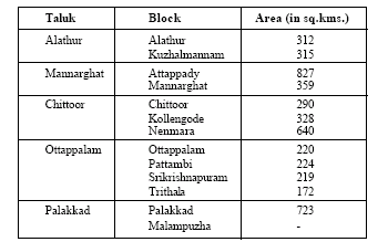
Alathur
The block is situated in the south central part of the district. It covers an area of 312 sq.kms. Paddy is, by far, the most important crop. Canals irrigate a net area of 7470 hectars.
Attappady
Attappady is the largest block in the district and is situated on the north east side over an area of 827 sq.kms. It is covered by hilly highland region endowed with the tributaries of the river Cauvery. Eventhough agriculture is the main activity, the net area sown is only about 12 per cent of the total land.
Chittoor
Chittoor block has an area of 290 sq.kms. and is situated in the south of the district. It has 19 villages, six panchayats and one town. About 75 per cent of the people depend on agriculture for their livelihood. Industry employs less than 8 per cent and the remaining find their employ-ment in the tertiary sector. The block has a geographical area of 29,000 hectares. There is hardly any forest in the block. It is endowed with good irrigation facility from the Chittoorpuzha project.
Kollengode
The block, located in the south central part of the district, covers an area of 328 sq.kms., with 13 villages, consisting of five panchayats. Agriculture is the main source of livelihood and employment for the majority. Paddy is the main crop, followed by groundnut and coconut. Nearly 70 per cent of the workers are employed in the primary sector, whereas the secondary sector accounts for 15 per cent. Dairying is a significant subsidiary occupation.
Kuzhalmannam
Kuzhalmannam block covers an area of 315 sq.kms. It contains 17 villages and eight panchayats. The population primarily depends on agriculture for livelihood. Paddy is the most important crop covering a gross area of 21,500 hectares. The main source of irrigation is canals and it accounts for 27,600 hectares.
Malampuzha
The Malampuzha block is carved out of Kuzhalmannam, Palakkad and Kollengode blocks. It comprises of eight panchayats. Most of the people are agricultural labourers. A large number of industrial establishments like the Indian Telephone Industries, Instrumentation Ltd., Fluid Control Centres, Malabar Cements etc., are situated in this block. A large number of other SSI units are also springing up in Kanjikode area. The famous Malampuzha Gardens is situated here. Paddy is the major crop of the block which sustains the majority.
Mannarghat
Mannarghat block has one town, 16 villages and eight panchayats, covering 359 sq.kms. The block is traversed by a network of rivers and rivulets. Thuthappuzha and its tributaries are a source of irrigation. Cultivable waste land constitutes more than 20 per cent of the area. Rice is cultivated in 11,540 hectares followed by rubber (2,840 htrs) and cashew nut (2,270 hectares). Industrially the block is backward.
Nenmara
The block, on the south of the district, covers an area of 640 sq.kms. The block consists of hill ranges and hence the density of population is very low. The area available for cultivation is limited due to the undulating surface of the hills, There is scope for development of dairying. Nelliampathy range is said to be ideal for rearing exotic breed of milch animals.
Ottapalam
The block, on the west of the district, covers an area of 220 sq.kms. It consists of nine villages and six panchayats. Agriculture continues to be a major economic activity. Paddy is the leading crop followed by tapioca, coconut and cashewnuts. Irrigated area is only 1,016 hectares; rivers contributing over 50 per cent followed by wells and tanks.
Palakkad
Palakkad ranks second only to Attappady in area and covers 723 sq.kms. The block, with two towns, 20 villages and constituting 12 panchayats. Economic activities are sustained by a labour force which forms 34 per cent of the population. Agriculture occupies the foremost position inproviding employment and as a source of livelihood. The net area sown is 17,200 htrs. whereas forests cover 4,500 hectares. and cultivable land (waste) 7500 hectares. Paddy occupies the foremost place in terms of cropped area accounting for 11,219 acres. Irrigation is available from canals for 17,656 acres, from wells, 531 acres and from other sources, 168 acres.
Pattambi
Pattambi is one among the small blocks of the district and has an area of 224 sq.kms., comprising of 11 panchayats, !3 villages and two towns. Agricultural sector continues to be the main source of employment. Apart from paddy, coconut occupies a very important place from the income point of view. It covers an area of over 2,800 hectares; of which only 106 hectares are brought under irrigation.
Srikrishnapuram
Srikrishnapuram covers an area of 219 sq.kms. with ten villages and six panchayats. Paddy is the important crop, followed by tapioca, cashewnut, vegetable and coconut.
Trithala
Trithala lies to the east of the district and is the smallest among all the blocks. Having an area of 172 sq.kms, it comprises of eight villages and seven panchayats. Agriculture is the major economic activity and is also a source of employment. The net area sown is over 44 per cent of the geographical area. Paddy is the major crop in the block. The next important crop is arecanut. Presently, irrigation is available to more than 4,400 hectares. Industrially the block is backward.
Content Courtesy: Department of Information & Public Relation